Geospatial Data Processing

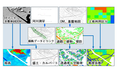
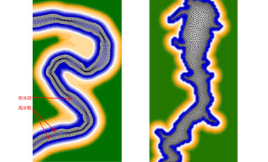
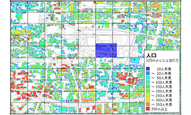
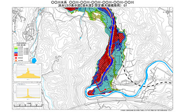
We provide solutions of various geographical information services, from geographical modeling linked with numerical simulations of fluid dynamics, river flood, inundation due to tsunami run-up/storm surge, through visualization of simulations, to the superposition of simulation images on background maps using GIS. In recent years, we extended our services to the drawing of refined geographical maps like river cross-section using laser profiler (LP) data, as well as to geographical modeling for analyses of landslide/inundation and so forth.

Category
Data mapping and processing
  • Data processing support for numerical simulations of inundation
  • Several kinds of data processing supports using laser profiler data
  • Data processing of NetCDF(Network Common Data Form) format data
Mesh generation
  • Structured mesh generation for curved geometry
  • Unstructured mesh generation for complicated geographic field
Mapping assets data and damage cost estimation
  • Creates grid base data of assets for assessing cost-effectiveness
  • Drawing maps of population, households, land use and the number of assets in terms of ordinary homes, enterprises and croplands
  • Evaluate the amount of damage estimated from the inundation results
Disaster Risk Map
  • Various hazard map
  • River flood hazard map
Our Projects
Numerical modelling support services
  • Data preparation and supports for Tsunami simulations, urban flood, storm surge, reservoir flow and 3D flow simulations
Disaster prevention related services
  • Creating map of inundation areas when reservoir bank bursts
  • Estimation of amount of damage due to flood inundation, and the Benefit Cost Ratio (BCR)
  • Creating hazard map draft published by local governments
Others
  • Estimation of water storage capacity in dam, utilizing laser profiler (LP) data
  • Structured/unstructured river mesh generation using GIS
  • Creating 1km-gridded network data of river channels

Others