


Flow Velocity and Rate Measurement software Using Video Images
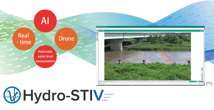
Hydro-STIV is software that measures flow velocity and flow rate using video and water level information.We have achieved high-precision measurement by integrating the latest STIV technology by Professor Emeritus Ichiro Fujita of Kobe University with our AI technology.It is possible to safely and easily measure the flow velocity and flow rate without approaching the river in the event of a danger such as a flood.
<References>
Fujita I. 2017. Discharge Measurements of Snowmelt Flood by Space-Time Image Velocimetry during the Night Using Far-Infrared Camera. Water 2017; 9(4); 269.
Fujita I, Watanabe K, Iguchi M, Hasegawa M. 2020. IMPROVEMENT OF STIV TECHNIQUE BY USING DEEP LEARNING,Annual journal of Hydraulic Engineering. JSCE; Vol.76; No.2.
- Point1 : On-site survey
- Point2 : STIV measurement
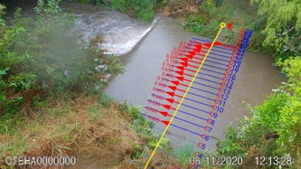
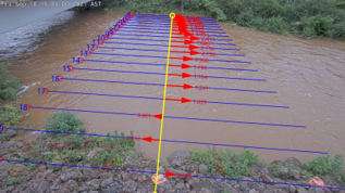
1. Procedure
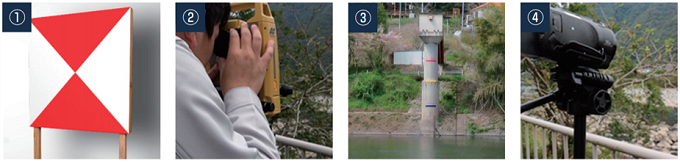
① Set up control points on both sides of the river
② Survey the control points coordinates
③ Aquire water level information
④ Shoot video
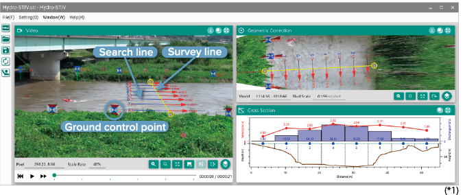
Utilizing wizard-formated guidance, you can easily measure with intuitive operation.
The measurement results can be output to HTML reports and used for reports and calculations.
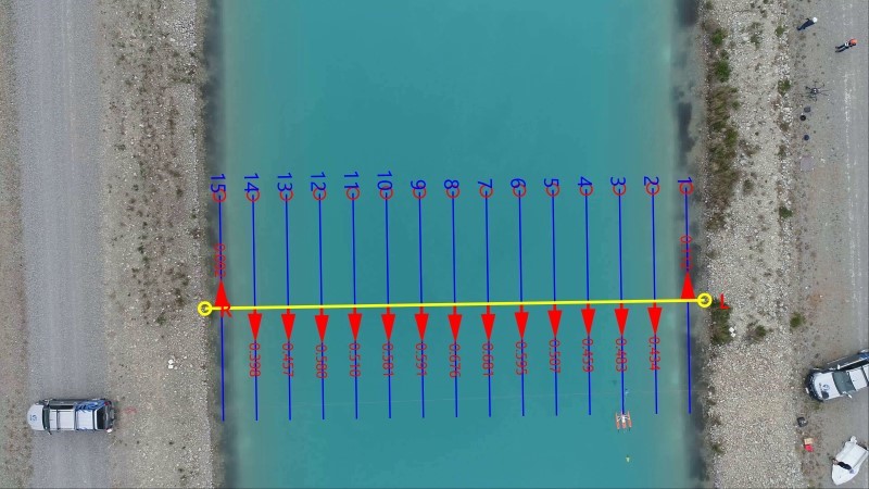
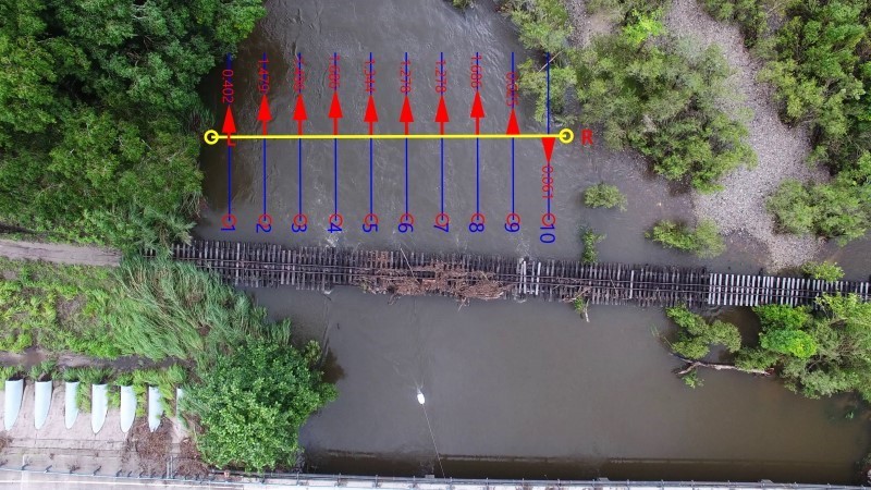
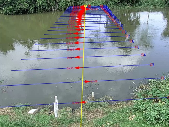
2. Theory:Velocity measurement with Space-Time Image
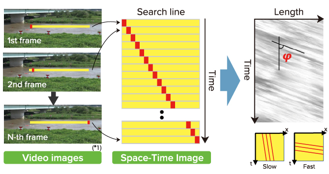
Left figures: Generation of Space-Time Image (STI) from video images
The yellow lines show search lines, and the red squares show features of brightness
values (surface ripples etc.). STI is generated by arranging the brightness values on the
search line in the time direction, and the stripe pattern indicates velocity.
Right figures: Calculation of Velocity (V) from STI
Velocity is calculated using slope of the stripe pattern (φ), length, and time of STI.
When φ is small, velocity is slow (left-bottom), and vice versa (right-bottom).
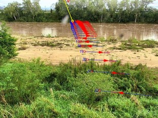
3. Accuracy:Evaluation of STIV measurement accuracy for velocity
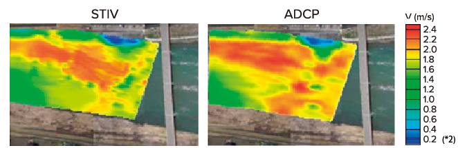
Left figure: STIV measurement using an areal photograph
Right figure: Acoustic Doppler Current Profiler (ADCP) measurement
STIV measurement well reproduces ADCP measurement of the flow distribution.
*This figure was created by using other drawing software to evaluate the accuracy.
4. Notable Points
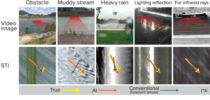
- Point1 : AI analysis - High Speed & High Accuracy
-
- Resistant to noise such as water droplets and blurring, and automates image analysis
- Automatically realizes stable flow velocity and flow rate measurement in various environments such as bad weather
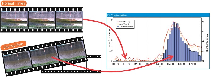
AI (deep learning) based image analysis realises more robust measurement than the conventional one. For example, noisy video images with obstacle, light, random noise, and waves, or night images can also be measured with high accuracy without manual parameter tuning.
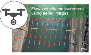
- Point2 : Drone can be used
-
- Supports images taken of wide rivers with poor visibility to the opposite bank
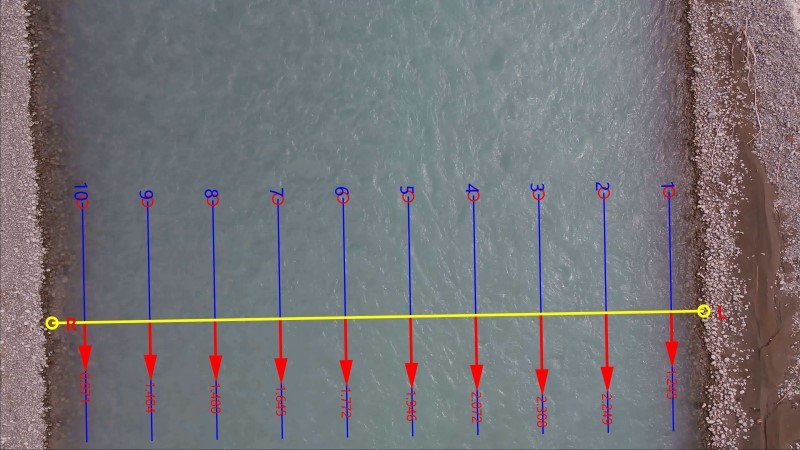
- It is possible to easily measure mountainous areas and rivers during floods, which are difficult for people to approach. It is possible to measure flow velocity and flow rate using images taken from the sky with a drone or the like. Taking pictures with a drone makes it possible to easily measure wide rivers with poor visibility to the opposite bank, challenging to approach mountainous areas, rivers during floods, etc. In the case of vertical shooting, there is no need for geometric correction. It is also an advantage that the actual scale can be known only by the distance between his two points on the image.
- Point3 : Real-time monitoring
-
- 24-hour real-time flow velocity/flow rate measurement is possible day and night
- Warning display of excess flow velocity/flow rate
We also offer a real-time measurement system using Hydro-STIV.
Flexible to customize
- Point4 : Automatic water level measurement function by image
-
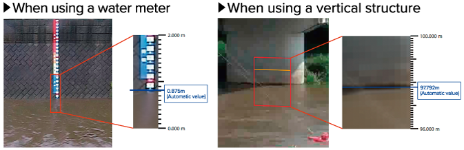
- Equipped with an automatic water level measurement function using images
- Automatically detect the water level from the image even if there is no gauge
The water level is measured by detecting the water edge on vertical structures such as gauges, piers, and concrete walls in the image.
The water level can be measured only with Hydro-STIV by using a gauge or by surveying a vertical structure.
Case Study
Othea River @ New Zealand |
Rangitata River @ New Zealand |
Tekapo River @ New Zealand |
Herbert River @ Australia |
@Melbourne, Victoria, Australia |
Russel River @ Australia |
North River @ Canada |
- Flow velocity and rate measurement by STIV
- Flow velocity measurement by PTV
- AI automation with high accuracy
- Measurement with images from drone
- Visualize flow velocity and rate along cross section
- Automatic processing for multiple images
- Automatic water level measurement function by image
- Video editing function (cutting out the measurement target section)
- Blur correction function
- Report output function
- File output function (png, csv, xml)
- GIS linkage function (kmz)
- Contact Infomation
- Please contact us if you have any questions.

Hydro-STIV Demo Using Drones and Fixed Camera videos
Country of introduction
(municipality, research institute, educational institution, corporation)
Australia, Canada, China, Finland, Korea, New Zealand, U.K., Vietnam
Main functions
System requirements
| System requirements | OS | Windows10(64-bit), Windows11 |
|---|---|---|
| CPU | Intel core i5 third generation or higher |
|
| Memory | 4 GB or more | |
| Resolution | 1920 x 1080 (Display) | |
| Video requirements | Format | avi, mp4, mov, wmv, m2ts |
| Scanning | Progressive | |
| Length | 15 to 30 seconds (Recommended) |
|
| Frame rate | 24 fps or more (Recommended) |
|
| Resolution | 720p, 1080p or more (Recommended) |
[Hydro-STIV] SOFTWARE LICENCE CONTRACT(PDF)
------------------------------------------------------------------------------------------------------
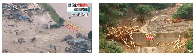
【References】 (*1) From joint research between International Centre for Water Hazard and Risk Management (ICHARM) and Ichiro Fujita Laboratory, Kobe University. (*2) Ichiro Fujita, Yuichi Notoya, Mitsuru Shimono: DEVELOPMENT OF AERIAL STIV APPLIED TO VIDEOTATED MOVIE FROM MULTICOPTER BASED ON HIGH-ACCURATE IMAGE STABILIZATION METHOD, JSCE Proceedings B1 (Hydraulic Engineering), Vol.71, No.4, I_829-I_834, 2015. (*3) Ichiro Fujita, Tatsushi Shibano, Kojiro Tani: IMPROVEMENT OF STIV FOR VIDEO IMAGES CAPTURED UNDER DETERIORATED MEASUREMENT CONDITIONS, JSCE Proceedings B1 (Hydraulic Engineering), Vol. 74, No.5, I_619 -I_624, 2018. (*4) From the Field Observation Workshop sponsored by the Japan Society of Civil Engineers Hydraulic Engineering Committee and the Subcommittee on Advanced Flow Observation Technology. (*5) Fujita I., Notoya Y. and Furuta T.:Measurement of inundating flow from a broken embankment by using video images shoot from a media helicopter,River Flow 2018. (*6) Created by processing data from HP of the Geospatial Information Authority of Japan(https://www.gsi.go.jp/BOUSAI/H29hukuoka_ooita-heavyrain.html)![]()
![]()
Copyright © Hydro Technology Institute Co., Ltd. All Rights Reserved.